A left turn at Keswick!
To enlarge photos, click on, to return to blog, click off the photo to the side.
I received my knee scan results and examined them with interest, hoping to discover why my knee was so painful during long descents. Results were early stage Osteoarthritis. Well that came as no surprise, having been a carpet fitter for over 25 years and still a professional carpet cleaner ongoing for the last 35 years. That follows 9 years army, so an active working life as well as an active non working life and now 70 years, of course there is bound to be some degree of wear & tear. To get away with 'early' stage is a bonus the way I see it. Then there is the Meniscus Tear and Bone Bruise with Marrow Odema. I have fair understanding of how the body and it's component work in general but that last bit, is a bit French to me but the way I understand it, is that somehow the bone has been damaged causing Marrow change.
Right but is any of that the cause of my knee pain, which has been hampering my activities especially for the last few months? I don't know is the answer and have the feeling that I am going to have to suffer more expense and have a face to face with a consultant to get a detailed opinion. In the meantime I will just carry on doing what I do as best I can.
The not knowing had been holding me back, but now I felt a sort of release and decided last minute to test things out on the Cumbria Way. I have done the route four times previously, twice in each direction, in between 28 and 30 hours for the 72 miles, all walking.
Setting off from Carlisle and carrying a full camping pack of 26lbs (12kg) I made good headway heading for Dalston, Bridge End and Caldbeck. I could feel the weight of my pack pulling me back some, but kept pushing forward, the aim being to not drop below an average of 3mph.
 Start/Finish Cumbria Way
 River Caldew Weir Carlisle.
 Wild Garlick.
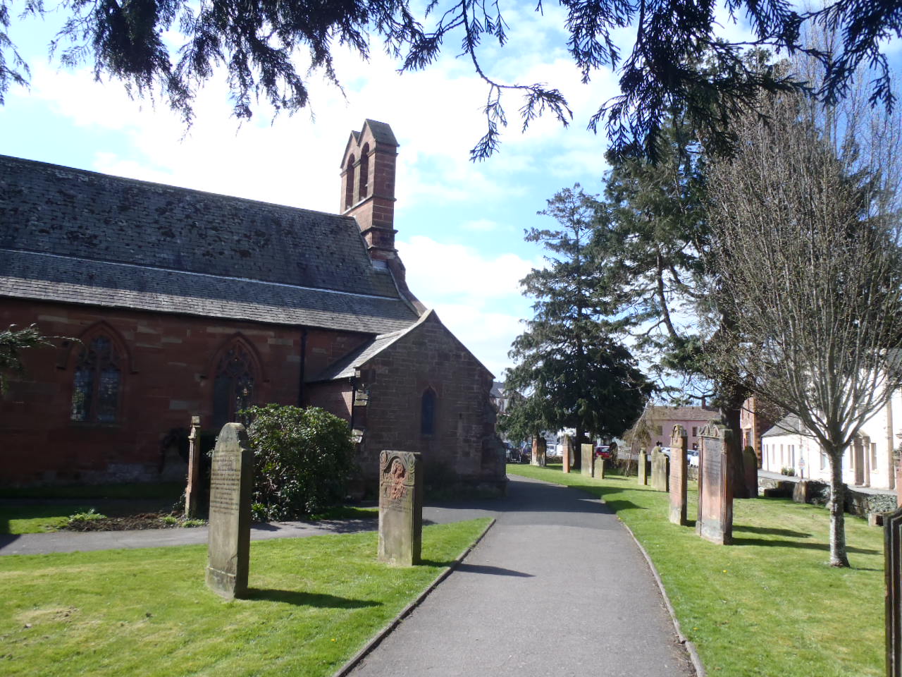
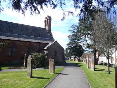 Dalston Church.
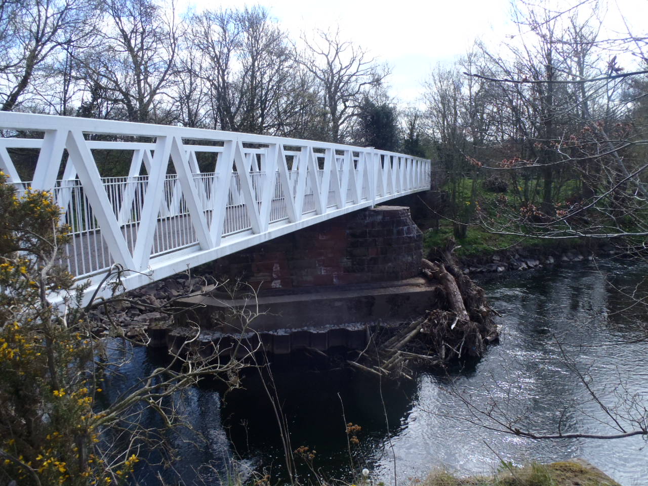
 Foot Bridge Dalston.
 Bridge End.
It was pleasant walking in good weather and at long last the ground had dried out, no more slipping and sliding through waterlogged fields. I was thrown a bit by some new builds which were not showing on my old guidebook. Stopped a few times chatting to locals and a couple of walkers.
The recent flooding devastation was apparent along by the river Caldew. Huge trees that had been swept away and now all tangled together in places, some having settled in fields as the water level dropped. River banks eroded and collapsed.
 Rose Bridge over the Caldew.
 Through woods alongside the river.
 Bog Bridge (Footbridge)
 Displaced tangled trees in river.

As I was approaching Bell Bridge where the route changes to the other side of the river, I looked ahead and could see that something didn't look right. It was clear as I got closer that the bridge was no longer there! I was later informed that it had been severely damaged during storm Desmond and closed as safety measure, then just last month it completely collapsed.
 Collapsed Bell Bridge.
Fortunately at this point a little lane stays on this side of the river leading down to where the way crosses back over at Sebergham Bridge which had survived. I walked down the lane and came across a closure notice. The lanes river bank had been undercut by the water. I managed to squeeze through at the side of the fence.
 Closed Lane from Bell Bridge.
 Undercut Road Bank.
 Place to squeeze through.
Further on the usual landslip in the woods on Old Bank Hill was much worse than last time I passed through this way, looking like the whole hillside could come down with the next heavy rain.

 Landslip looking precarious!
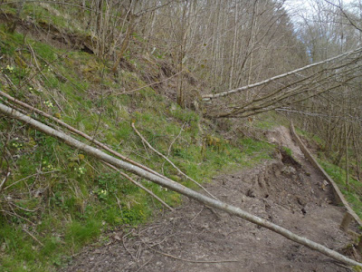 Path through landslip.
Into Caldbeck in good time, I re-supplied with water at the local shop then had a coffee and soup in the cafe. I stayed there for half an hour before continuing.
 Caldbeck in sight.
 Cald Beck at Caldbeck.
 Caldbeck Church.
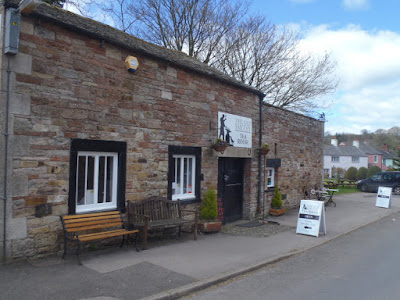 Cafe in Caldbeck.
Past Nether Row the long plod up High Pike felt harder than I remember - heavier pack or lack of fitness - or even being around ten years older- may have had something to do with that.
 Nether Row.

 Track up High Pike.

Anyway the top soon reached and my knee having been fine to this point now began complaining during the drop off and was screaming before I had descended to Grainsgill Beck.
 High Pike Summit.
 The drop off High Pike.
 The descent into Grainsgill Beck.


Once on the level heading for Skiddaw House YHA it settled. it always seems to take along time with the YHA not getting any closer along this stretch at the 'Back O Skiddaw'.
After that the path taking me on the mid reaches of Lonscale Fell, by passing Latrigg towards Keswick which I had planned on reaching within 10 hours for the 30 miles from Carlisle. I was in fact 15 minutes in credit!
 A Distant Skiddaw House YHA.
 Skiddaw House.
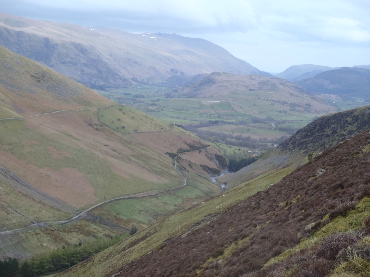
 Cumbria Way below Lonscale Fell.


 Keswick in View alongside Latrigg.
 Bridge out of Fitz Park Keswick.
However The knee pain during those descents left me dreading the drop off Stake Pass into Langdale and I had decided before I reached Keswick that I would not carry on with the route.
More devastation in Keswick, the footbridge in Fitz Park had gone along with the grass on the flooded fields which was being resurfaced and seeded. The B&B's closest to the river and a way up the side streets were all empty with builders equipment inside. I managed to find accommodation quite quickly though.
I had it in mind to simply catch the bus to Windermere and the train from there. It was a beautiful morning though with not a cloud in the sky, so I decided to walk to Penrith and get the train from there.
Having no map for this section it was tricky with a combination of paths, tracks, old railway, and minor roads and lanes.
My first mistake was dropping onto the old railway track, thinking that I was beyond where the two bridges had been washed away - I wasn't and had to backtrack. Up the road past Castlerigg Stone Circle and into Chapel Le Dale I started up the Old Coach Road.
 Leaving Keswick with Skiddaw in background.
 Old Railway Track.
 Blencathra.
 Castlerigg Stone Circle.

 Approaching Chapel Le Dale.
 Start of the Old Coach Road.


 Threllkeld.
 Blencathra Ridges.
Then thinking I could rejoin the Old Railway, as someone told me, I dropped down to it. I did manage to walk a couple of miles along it before having to escape it's confines and find another way. I did this and passed through GreystoKe before arriving finally in Penrith.
 Great Mell Fell.
 Old A66 to Penrith with new road alongside.

 Greystoke.
 Penrith in view.
 Penrith with Cross Fell and Gt. Dunn Fell in the distance.
From here they were bussing us to Preston, then the train to Chorley where I had left the car to drive home.
Even though I didn't manage the full Cumbria Way, I still got another 52 miles in and enjoyed the walk.
My knee quickly settled, feet and legs no problems, just have to see how it goes, but in the meantime, carrying on as normal.
To enlarge photos, click on, to return to blog, click off the photo to the side.
I received my knee scan results and examined them with interest, hoping to discover why my knee was so painful during long descents. Results were early stage Osteoarthritis. Well that came as no surprise, having been a carpet fitter for over 25 years and still a professional carpet cleaner ongoing for the last 35 years. That follows 9 years army, so an active working life as well as an active non working life and now 70 years, of course there is bound to be some degree of wear & tear. To get away with 'early' stage is a bonus the way I see it. Then there is the Meniscus Tear and Bone Bruise with Marrow Odema. I have fair understanding of how the body and it's component work in general but that last bit, is a bit French to me but the way I understand it, is that somehow the bone has been damaged causing Marrow change.
Right but is any of that the cause of my knee pain, which has been hampering my activities especially for the last few months? I don't know is the answer and have the feeling that I am going to have to suffer more expense and have a face to face with a consultant to get a detailed opinion. In the meantime I will just carry on doing what I do as best I can.
The not knowing had been holding me back, but now I felt a sort of release and decided last minute to test things out on the Cumbria Way. I have done the route four times previously, twice in each direction, in between 28 and 30 hours for the 72 miles, all walking.
Setting off from Carlisle and carrying a full camping pack of 26lbs (12kg) I made good headway heading for Dalston, Bridge End and Caldbeck. I could feel the weight of my pack pulling me back some, but kept pushing forward, the aim being to not drop below an average of 3mph.


It was pleasant walking in good weather and at long last the ground had dried out, no more slipping and sliding through waterlogged fields. I was thrown a bit by some new builds which were not showing on my old guidebook. Stopped a few times chatting to locals and a couple of walkers.
The recent flooding devastation was apparent along by the river Caldew. Huge trees that had been swept away and now all tangled together in places, some having settled in fields as the water level dropped. River banks eroded and collapsed.


As I was approaching Bell Bridge where the route changes to the other side of the river, I looked ahead and could see that something didn't look right. It was clear as I got closer that the bridge was no longer there! I was later informed that it had been severely damaged during storm Desmond and closed as safety measure, then just last month it completely collapsed.

Fortunately at this point a little lane stays on this side of the river leading down to where the way crosses back over at Sebergham Bridge which had survived. I walked down the lane and came across a closure notice. The lanes river bank had been undercut by the water. I managed to squeeze through at the side of the fence.


Further on the usual landslip in the woods on Old Bank Hill was much worse than last time I passed through this way, looking like the whole hillside could come down with the next heavy rain.


Into Caldbeck in good time, I re-supplied with water at the local shop then had a coffee and soup in the cafe. I stayed there for half an hour before continuing.


Past Nether Row the long plod up High Pike felt harder than I remember - heavier pack or lack of fitness - or even being around ten years older- may have had something to do with that.


Anyway the top soon reached and my knee having been fine to this point now began complaining during the drop off and was screaming before I had descended to Grainsgill Beck.


Once on the level heading for Skiddaw House YHA it settled. it always seems to take along time with the YHA not getting any closer along this stretch at the 'Back O Skiddaw'.
After that the path taking me on the mid reaches of Lonscale Fell, by passing Latrigg towards Keswick which I had planned on reaching within 10 hours for the 30 miles from Carlisle. I was in fact 15 minutes in credit!


However The knee pain during those descents left me dreading the drop off Stake Pass into Langdale and I had decided before I reached Keswick that I would not carry on with the route.
More devastation in Keswick, the footbridge in Fitz Park had gone along with the grass on the flooded fields which was being resurfaced and seeded. The B&B's closest to the river and a way up the side streets were all empty with builders equipment inside. I managed to find accommodation quite quickly though.
I had it in mind to simply catch the bus to Windermere and the train from there. It was a beautiful morning though with not a cloud in the sky, so I decided to walk to Penrith and get the train from there.
Having no map for this section it was tricky with a combination of paths, tracks, old railway, and minor roads and lanes.
My first mistake was dropping onto the old railway track, thinking that I was beyond where the two bridges had been washed away - I wasn't and had to backtrack. Up the road past Castlerigg Stone Circle and into Chapel Le Dale I started up the Old Coach Road.


Then thinking I could rejoin the Old Railway, as someone told me, I dropped down to it. I did manage to walk a couple of miles along it before having to escape it's confines and find another way. I did this and passed through GreystoKe before arriving finally in Penrith.


From here they were bussing us to Preston, then the train to Chorley where I had left the car to drive home.
Even though I didn't manage the full Cumbria Way, I still got another 52 miles in and enjoyed the walk.
My knee quickly settled, feet and legs no problems, just have to see how it goes, but in the meantime, carrying on as normal.
No comments:
Post a Comment